
The Registration Convention is one of the international treaties which regulates the space environment. Implemented in the 1970s, it requires nation states to inform the United Nations about the orbits of the satellites that they launch into space.
In order to comply with this requirement, the UK Space Agency maintains the UK Registry of Outer Space Objects; a chronological listing of those objects in orbit for which the UK is legally responsible. The first entry in the UK Registry is Skynet 1A, an early military communication satellite which was launched to geostationary orbit in 1969. As a result of subsequent re-entries by earlier UK missions, it is now the oldest UK payload in space.
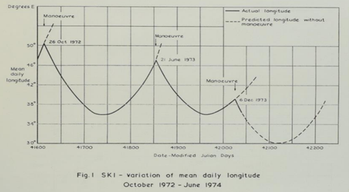
Skynet 1A was built by Ford Aerospace in the USA, and launched from Florida in late 1969. After checkout by the Americans, it was drifted across the Atlantic, and commenced operations at a longitude of around 40 East on the geostationary arc, controlled by a team based at the Royal Aircraft Establishment (RAE) at Farnborough. A series of six RAE reports were written detailing the operations of Skynet 1A between early 1970 and late 1973. They confirm that Skynet 1A was still in the gravitational well that is centred on 75 East at the end of 1973.
At this point in the story, a brief diversion into orbital mechanics is necessary. Due to the asphericity of the Earth, and the gravitational attractions of the Sun and the Moon, an uncontrolled geostationary satellite will experience both East-West and North-South perturbations to its orbit.
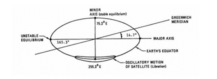 The East-West motion is an oscillation about one of the gravitational “wells” which are located at about 75 East or 105 West on the geostationary ring. The period of this oscillation is around 800 days, and the amplitude of the “swing” is related to the original location of the satellite relative to the bottom of the well. So, if Skynet-1A had failed at its operational location of around 40 East, we would now expect it to be oscillating by +/- 35 degrees either side of 75 East.
Except that it isn’t. According to the UK Registry , Skynet-1A is currently sitting very close to the bottom of the other well at 105 West, oscillating by just a couple of degrees. This initially looks like a case of mistaken identity – after all how could a UK satellite end up in a slot half a world away, to the west of the Americas?
The hypothesis that the object at 105 West actually is the UK’s satellite is testable, due to the North-South perturbations on its orbit. These perturbations would increase its inclination up to a value of 15 degrees and then start to bring it down again towards zero – with a complete cycle taking about 54 years. So now, nearly 54 years after its launch, we would expect Skynet-1A satellite to be back very close to an inclination of zero degrees, and somewhat surprisingly, the object at 105 West passes this test.
You might wonder why there is any doubt about the identity of the object at 105 West at all, since, if the satellite had been tracked continuously since its launch, there would clearly be no ambiguity. Unfortunately, however, this is not the case. The plot below shows all the US Space Command orbital data held by the UK MOD on this object up to 2016, and it is very clear that there are two extended periods when it was not tracked at all, (or where the data has been lost), including the crucial period, sometime in the mid-1970s, where it appears to have changed longitude from around 40 East to 105 West.

Physics doesn’t support the idea that this change in longitude could have happened as a result of natural perturbations, and this strongly implies a deliberate sequence of commands to move the satellite – one manoeuvre to initiate the drift in longitude, and another to stop it at its current location.
You might assume that a deliberate series of manoeuvres, even if conducted nearly 50 years ago, would have been documented somewhere, (especially since at least two nationalities must have been involved in the process, because 105 West is simply not visible from the UK). And some identity information must have led US Space Command to associate this object with Skynet-1A in about 1977 and 1990, when it seems that they recommenced tracking it after (apparently) long periods without data. (There is some ambiguity here, since US Space Command has definitely “lost” historical orbital data in the past, and it could be that Skynet-1A was one of the satellites affected. In this scenario, the satellite is actually tracked throughout its lifetime, its identity is never in question, and the long gaps in between orbital element sets (elsets) are simply the result of lost data. The alternate hypothesis is that GEO missions were in their infancy when the satellite was launched, and that contemporaneous tracking data was simply unavailable for small, uncooperative targets more than 35,000 km away. In this scenario, the gaps in orbital data are real).
However, on the UK side of Atlantic at least, records seem to have been lost. A search of the National Archives at Kew provides no data on any planned disposal of the satellite, and UK operators who were involved with the satellite at the time have no recollection of a decision to move the satellite back across the Atlantic.
Does any of this have implications for the UK today? Well arguably it does, since we are still legally liable for the satellite. Moreover, since it wasn’t moved into a graveyard orbit, (an end-of-life disposal concept that comfortably post-dates Skynet-1A), it still represents a hazard to other geostationary missions in the vicinity of 105 West. Disappointingly, because Skynet-1A sits at the bottom of a gravity well, there is a lot of passing traffic. The diagram below, (taken from Paul Anderson’s fine PhD thesis), shows how conjunction probabilities in the geostationary region are concentrated at 75 East and 105 West.
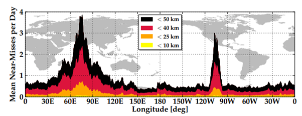
There is still a need to confirm the identity of the object at 105 West, but if it is Skynet-1A, whoever moved it there did the UK no favours. As the diagram above shows, it is likely to collide with something one day, and unless further evidence emerges, the launching state, (the UK), will be held liable…….except there is currently nothing to show that the UK is “responsible” for the satellite’s current position. It could have been moved by someone else, and the last person to send it a manoeuvre command in the 1970s, (to stop it at 105 West), almost certainly spoke with an American accent.
Stuart, an interesting article for those interested in early Milsatcoms and the implications for uncontrolled orbital objects.
The question Stu, was who was the last UK operation to command 1A?
Rick
Lovely article, Stuart. We’re both just too young to have been involved personally with this one…
Wow. Echostar 105 / SES 11 is operational at 105 west now. Is this thing in an inclined parking orbit “above” the Clarke belt? I mean, it’s got to be in an inclined “figure 8” pattern but was it bumped up and parked just beyond the geostationary belt? I believe that would explain a slow “westward drift” over 45 years… but I haven’t had coffee yet 😆
Assume the obvious (send a “who are you?” command to the object) can’t be done for some reason? Or is the satellite defunct?
Hello Stuart,
Wonderful writeup, and nice to see the articles making the rounds about this discovery. Why are we looking into this now, when the data which might have led to this discovery predated 2023 by several years? Would love to know more about the genesis of this article.
It’s an interesting coincidence that 105 deg West is just about the longitude of Colorado Springs. Could this be a case of DENIAL space combat operations ?
Also, what is in 75 deg East lookin northward over India into central Russia ?
Just speculating further.